


DJI Phantom 4 RTK Drone
Same day dispatch, Order before 2:30 PM
30 days easy returns
24 / 7 support service
Cash on Delivery option available
1-Year Software Warranty
Buy DJI Phantom 4 RTK Drone at the Best Price in India
Upgrade your mapping missions using the Phantom 4 RTK. It's a small and super precise mapping tool that flies low. It's got cool features like a 1-inch CMOS sensor, an RTK module, and a smart GS RTK app. Plus, it syncs time, connects easily with OcuSync, and works with D-RTK 2 GNSS Mobile Station. This means it's accurate down to 1cm horizontally and 1.5cm vertically, with 5cm precision for photogrammetric models. You can plan flights using the GS RTK app and collect RTK data hassle-free, making it perfect for surveys, maps, or inspections right from the start.
The DJI Phantom 4 RTK Drone is a powerful and precise tool designed for professional aerial surveying and mapping. Equipped with a high-precision RTK (Real-Time Kinematic) module, it ensures centimeter-level accuracy for geospatial data collection, making it ideal for industries such as construction, agriculture, and mining. The drone features a robust 1-inch 20 MP CMOS sensor that captures detailed, high-quality images and video, supported by a mechanical shutter that eliminates rolling shutter distortion. With its advanced FlightAutonomy system, the Phantom 4 RTK offers enhanced obstacle avoidance and automated flight control, ensuring safe and reliable operation in complex environments. The drone is also equipped with a powerful 5870 mAh battery, providing up to 30 minutes of flight time on a single charge. The integrated RTK module offers real-time corrections to GPS data, significantly improving positional accuracy. Its rugged design includes intelligent flight modes and an improved remote controller with a built-in screen for clear, real-time telemetry and control. Additionally, the drone supports DJI's P4 RTK Base Station for even greater accuracy and flexibility in field operations. Whether you're conducting detailed surveys, creating precise maps, or inspecting large areas, the DJI Phantom 4 RTK Drone delivers exceptional performance and reliability for demanding aerial tasks.
Centimeter-Level Accuracy: Equipped with RTK technology, providing highly accurate geospatial data for precise mapping and surveying.
High-Quality Imaging: Features a 1-inch 20 MP CMOS sensor for detailed and sharp images.
Mechanical Shutter: Eliminates rolling shutter distortion, ensuring clear and accurate image capture.
Advanced FlightAutonomy: Enhances safety with obstacle avoidance and intelligent flight control systems.
Extended Flight Time: Offers up to 30 minutes of flight time with a powerful 5870 mAh battery.
Real-Time Data Corrections: RTK module provides real-time GPS data corrections for improved positional accuracy.
Intelligent Flight Modes: Includes various automated flight modes for complex surveying and mapping tasks.
Built-In Remote Controller Screen: Features a remote controller with a built-in screen for clear, real-time telemetry and control.
Enhanced Durability: Rugged design built to withstand demanding field conditions and challenging environments.
Integrated RTK Base Station Support: Compatible with DJI's P4 RTK Base Station for additional accuracy and flexibility.
High Precision for Professional Use: Ideal for industries such as construction, agriculture, and mining where precise data is critical.
Easy Integration: Compatible with various data processing and GIS software for streamlined workflow integration.
Automated Flight Path Planning: Allows users to set predefined flight paths for consistent and repeatable data collection.
Safety Features: Includes features like return-to-home, fail-safe mechanisms, and obstacle detection for safe operations.
User-Friendly Interface: Designed with an intuitive user interface, making it accessible for both experienced pilots and beginners.

DJI Phantom 4 RTK Drone is a sophisticated aerial solution designed for high-precision surveying and mapping.
It features an RTK (Real-Time Kinematic) module that provides centimeter-level accuracy, making it ideal for professional applications such as construction, agriculture, and environmental monitoring.
The drone is equipped with a 1-inch 20 MP CMOS sensor that delivers high-quality imagery, while its mechanical shutter helps eliminate image distortion.
With a maximum service ceiling of 19,685 feet (6,000 meters) and a top speed of 36 mph (58 kph) in A-mode, the Phantom 4 RTK is built to handle a variety of demanding tasks.
It offers up to 30 minutes of flight time on a single charge and operates effectively within a temperature range of 32° to 104° F (0° to 40℃).
The drone features advanced FlightAutonomy technology for enhanced safety with obstacle avoidance and automated flight control.
The integrated RTK module ensures real-time GPS corrections, improving positional accuracy.
The remote controller includes a built-in screen for clear, real-time telemetry and control, and the drone supports various intelligent flight modes for automated data collection.
The Phantom 4 RTK is designed for durability, with a rugged construction capable of withstanding challenging field conditions.
It supports an array of accessories, including an Intelligent Battery Charging Hub and a carrying case, making it a comprehensive tool for precise aerial data collection.

The DJI Phantom 4 RTK is a cutting-edge aerial platform designed for precise and efficient surveying and mapping. Equipped with advanced RTK (Real-Time Kinematic) technology, the Phantom 4 RTK offers high-accuracy positioning to meet demanding professional needs. With its 1-inch CMOS sensor, the drone captures high-resolution images at 20 megapixels, ensuring detailed and clear data collection. The camera features an 84° field of view and a versatile lens with an aperture range of f/2.8 to f/11, allowing for optimal imaging in various lighting conditions. The Phantom 4 RTK supports multiple GNSS systems, including GPS, GLONASS, BeiDou, and Galileo, enhancing its positioning accuracy and reliability.
The drone's robust build and intelligent flight features enable it to operate efficiently in various environments. Its obstacle sensing system includes a range of sensors and cameras, providing a comprehensive view of its surroundings to avoid collisions. The Phantom 4 RTK boasts an impressive maximum flight time of approximately 30 minutes and can achieve speeds of up to 31 mph (50 kph). With a maximum service ceiling of 19,685 feet (6,000 meters), it is suitable for high-altitude operations.
Designed for ease of use, the Phantom 4 RTK includes a remote controller with a 5.5-inch screen, offering clear visibility even in bright conditions. It supports a wide range of mobile devices and provides a user-friendly interface for seamless operation. The drone's built-in battery offers substantial power, with a capacity of 5870 mAh and a maximum charging power of 160 W. The Phantom 4 RTK also features comprehensive data storage options, supporting microSD cards up to 128 GB with high-speed write capabilities.
Whether for precision agriculture, construction, mining, or infrastructure inspection, the DJI Phantom 4 RTK provides professionals with reliable, high-accuracy aerial data to support their projects and enhance decision-making processes.
When you're looking to buy the DJI Phantom 4 RTK Drone Everse offers some standout advantages. First off, we provide the drone at the best price you'll find in India, ensuring you get great value for your money. Plus, your purchase comes in a securely sealed package, guaranteeing its condition upon arrival. With delivery times of just 5 to 7 days, we pride ourselves on being the fastest in the business, prioritizing your convenience. What's more, our commitment doesn't end with the sale—we have repair and service centers to assist you even after the warranty expires. Count on Everse for a smooth drone shopping experience and ongoing customer
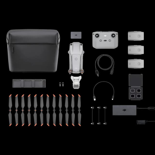
In The Box
- Aircraft Body × 1
- Remote Controller × 1
- Propeller Pair × 4
- Intelligent Flight Battery × 2
- AC Power Cable × 1
- WB37 Remote Controller Intelligent Battery × 1
- AC Power Adapter × 1
- Intelligent Battery Charging Hub × 1
- Intelligent Flight Battery Charging Hub × 1
- Gimbal Clamp × 1
- MicroSD Card (16GB) × 1
- Carrying Case × 1
- Micro USB Cable × 1
- USB-C Cable × 1
- USB-C OTG Cable × 1
- Phillips Screw × 2
- Takeoff Weight:
1391 g - Diagonal Distance:
350 mm - Max Service Ceiling Above Sea Level:
19685 ft (6000 m) - Max Ascent Speed:
6 m/s (automatic flight); 5 m/s (manual control) - Max Descent Speed:
3 m/s - Max Speed:
31 mph (50 kph) (P-mode)
36 mph (58 kph) (A-mode) - Max Flight Time:
Approx. 30 minutes - Operating Temperature Range:
32° to 104° F (0° to 40℃) - Operating Frequency:
2.400 GHz to 2.483 GHz (Europe, Japan, Korea)
5.725 GHz to 5.850 GHz (United States, China) - Transmission Power (EIRP):
2.4 GHz
CE (Europe) / MIC (Japan) / KCC (Korea) : < 20 dBm
5.8 GHz
SRRC (China) / FCC (United States) / NCC (Taiwan, China) : < 26 dBm - Hover Accuracy Range:
RTK enabled and functioning properly:
Vertical: ±0.1 m
Horizontal: ±0.1 m
RTK disabled
Vertical: ±0.1 m (with vision positioning)
±0.5 m (with GNSS positioning)
Horizontal: ±0.3 m (with vision positioning)
±1.5 m (with GNSS positioning) - Image Position Offset:
The position of the camera center is relative to the phase center of the onboard D-RTK antenna under the aircraft body's axis: (36, 0, and 192 mm) already applied to the image coordinates in Exif data.
The positive x, y, and z axes of the aircraft body point to the forward, rightward, and downward of the aircraft, respectively.
- Stabilization:
3-axis (tilt, roll, yaw) - Pitch:
-90° to +30° - Max Controllable Angular Speed:
90°/s - Angular Vibration Range:
±0.02°
- Single-Frequency, High-Sensitivity GNSS Module:
GPS + BeiDou + Galileo (Asia)
GPS + GLONASS + Galileo (other regions) - Multi-Frequency Multi-System High-Precision RTK GNSS
- Frequency Used:
GPS: L1/L2
GLONASS: L1/L2
BeiDou: B1/B2
Galileo: E1/E5a - First-Fixed Time:
< 50 s - Positioning Accuracy:
Vertical: 1.5 cm + 1 ppm (RMS)
Horizontal: 1 cm + 1 ppm (RMS)
1 ppm means the error has a 1 mm increase for every 1 km of movement from the aircraft.
- Mapping Accuracy:
Mapping accuracy meets the requirements of the ASPRS Accuracy Standards for Digital Orthophotos Class III.
Note: The actual accuracy depends on surrounding lighting and patterns, aircraft altitude, mapping software used, and other factors when shooting. - Ground Sample Distance (GSD):
(H/36.5) cm/pixel
H means the aircraft altitude relative to the shooting scene (unit: m). - Data Acquisition Efficiency:
Max operating area of approx. 1 km² for a single flight (at an altitude of 182 m, i.e., GSD is approx. 5 cm/pixel), meeting the requirements of the ASPRS Accuracy Standards for Digital Orthophotos Class III.
- Velocity Range:
≤ 31 mph (50 kph) at 6.6 ft (2 m) above ground with adequate lighting - Altitude Range:
0 - 33 ft (0 - 10 m) - Operating Range:
0 - 33 ft (0 - 10 m) - Obstacle Sensing Range:
2 - 98 ft (0.7 - 30 m) - FOV:
Forward/Rear: 60° (horizontal), ±27° (vertical)
Downward: 70° (front and rear), 50° (left and right) - Measuring Frequency:
Forward/Rear: 10 Hz
Downward: 20 Hz - Operating Environment:
Surfaces with clear patterns and adequate lighting (> 15 lux)
- Obstacle Sensing Range:
0.6 - 23 ft (0.2 - 7 m) - FOV:
70° (Horizontal)
±10° (Vertical) - Measuring Frequency:
10 Hz - Operating Environment:
Surface with diffuse reflection material, and reflectivity > 8% (such as walls, trees, humans, etc.)
- Sensor:
1" CMOS; Effective pixels: 20 MP - Lens:
FOV: 84°
8.8 mm / 24 mm (35 mm format equivalent: 24 mm)
f/2.8 - f/11, auto focus at 1 m - ∞ - ISO Range:
Video: 100-3200 (Auto)
100-6400 (Manual)
Photo: 100-3200 (Auto)
100-12800 (Manual) - Mechanical Shutter Speed:
8 - 1/2000 s - Electronic Shutter Speed:
8 - 1/8000 s - Max Image Size:
4864 × 3648 (4:3)
5472 × 3648 (3:2) - Video Recording Modes:
H.264, 4K: 3840 × 2160 30p - Photo Format:
JPEG - Video Format:
MOV - Supported File Systems:
FAT32 (≤ 32 GB)
exFAT (> 32 GB) - Supported SD Cards:
MicroSD, Max Capacity: 128 GB. Class 10 or UHS-1 rating required. Write speed ≥ 15 MB/s - Operating Temperature Range:
32° to 104° F (0° to 40℃)
- Operating Frequency:
2.400 GHz - 2.483 GHz (Europe, Japan, Korea)
5.725 GHz - 5.850 GHz (United States, China) - Transmission Power (EIRP):
2.4 GHz:
CE / MIC / KCC: < 20 dBm
5.8 GHz:
SRRC / FCC: < 26 dBm - Max Transmission Distance:
FCC: 4.3 mi (7 km)
SRRC / CE / MIC / KCC: 3.1 mi (5 km) (Unobstructed, free of interference) - Power Consumption:
16 W (typical value) - Display:
5.5 inch screen, 1920 × 1080, 1000 cd/m², Android System - Memory:
4 GB RAM + 16 GB ROM - Operating Temperature Range:
32° to 104° F (0° to 40℃)
- Capacity:
5870 mAh - Voltage:
15.2 V - Battery Type:
LiPo 4S - Energy:
89.2 Wh - Net Weight:
468 g - Charging Temperature Range:
14° to 104° F (-10° to 40° C) - Max Charging Power:
160 W
- Voltage:
17.5 V - Operating Temperature Range:
41° to 104° F (5° to 40° C) - Capacity:
4920 mAh - Voltage:
7.6 V - Battery Type:
LiPo 2S - Energy:
37.39 Wh - Operating Temperature:
-4° to 104° F (-20° to 40° C)
- Input Voltage:
17.3 - 26.2 V - Output Voltage and Current:
8.7 V, 6 A
5 V, 2 A - Operating Temperature:
41° to 104° F (5° to 40° C)
- Input Voltage:
17.3 - 26.2 V - Output Voltage and Current:
8.7 V, 6 A
5 V, 2 A - Operating Temperature:
41° to 104° F (5° to 40° C)
- Operating Frequency:
2.400 GHz to 2.483 GHz (Europe, Japan, Korea)
5.725 GHz to 5.850 GHz (Other countries/regions) - EIRP:
2.4 GHz:
CE / MIC / KCC: < 20 dBm
5.8 GHz:
FCC / SRRC / NCC: < 26 dBm - Max Transmission Distance:
FCC / NCC: 4.3 mi (7 km)
CE / MIC / KCC / SRRC: 3.1 mi (5 km) (Unobstructed, free of interference) - Built-in Battery:
6000 mAh LiPo 2S - Operating Current / Voltage:
1.2 A @ 7.4 V - Mobile Device Holder:
Tablets and smartphones - Operating Temperature:
32° to 104° F (0° to 40° C)
Company Vision
From intelligent drones to humanoid and companion robots, we bring innovation that empowers industries, creators, and communities for a smarter, connected future.

Trusted by Industry Leaders


%20Basic%20Combo%20Drone.webp&w=640&q=75)
.webp&w=640&q=75)
.webp&w=640&q=75)
.webp&w=640&q=75)
.webp&w=640&q=75)

.webp&w=640&q=75)

.webp&w=640&q=75)
.webp&w=640&q=75)
