DJI P4 Multispectral Drone
Same day dispatch, Order before 2:30 PM
30 days easy returns
24 / 7 support service
Cash on Delivery option available
1-Year Software Warranty
Buy DJI P4 Multispectral Drone at the Best Price in India
The DJI P4 Multispectral Drone is a sophisticated tool designed for precision agriculture and environmental monitoring. Equipped with a high-resolution multispectral camera, it captures detailed images across multiple spectral bands, allowing for precise analysis of crop health and vegetation. The drone's advanced imaging system provides critical data for monitoring plant health, detecting pests, and optimizing irrigation. With its robust flight capabilities and accurate GPS, the P4 Multispectral ensures reliable data collection over large areas. Its integration with DJI’s software enables seamless data analysis and actionable insights. The drone's compact design and easy deployment make it ideal for field operations. Its high endurance and automated flight planning enhance efficiency and productivity. This drone is a game-changer for agricultural professionals seeking to improve yields and sustainability. The DJI P4 Multispectral delivers the technology needed for informed decision-making and advanced agricultural management.
Precision Agriculture: The DJI P4 Multispectral Drone offers unparalleled accuracy in monitoring crop health through its high-resolution multispectral camera. By capturing detailed images in multiple spectral bands, it allows farmers to make data-driven decisions, ensuring optimal crop management and increased yields.
Advanced Imaging Technology: This drone features an advanced multispectral camera that provides comprehensive insights into plant health. With the ability to capture images in various spectral bands, it enables precise analysis of vegetation, helping to identify stressors, nutrient deficiencies, and disease early.
Enhanced Efficiency: The DJI P4 Multispectral Drone streamlines field operations with its robust flight capabilities and precise GPS navigation. Its high endurance and automated flight planning reduce the time and effort required for data collection, making it a valuable tool for large-scale agricultural operations.
Real-Time Data Collection: With real-time data transmission, the P4 Multispectral Drone allows for immediate analysis of captured images. This feature is crucial for making timely decisions and adjustments in the field, ultimately enhancing operational efficiency and effectiveness.
Comprehensive Analysis: Integrated with DJI’s advanced software, this drone facilitates seamless data analysis. Users can generate detailed reports and actionable insights from the collected imagery, aiding in the development of targeted strategies for crop management and environmental monitoring.
Improved Crop Health Monitoring: By providing detailed information on plant health, the DJI P4 Multispectral Drone helps in early detection of potential issues such as pests, diseases, or water stress. This proactive approach allows for timely interventions, ensuring better crop health and productivity.
Cost-Effective Solution: Investing in the DJI P4 Multispectral Drone is a cost-effective choice for agricultural professionals. Its ability to reduce manual labor and improve precision in monitoring and management translates to significant long-term savings and increased profitability.
Ease of Use: Designed with user-friendliness in mind, the P4 Multispectral Drone is easy to operate and deploy. Its intuitive controls and automated features ensure that even those new to drone technology can quickly and efficiently collect valuable data.
Durability and Reliability: The DJI P4 Multispectral Drone is built to withstand various environmental conditions. Its robust construction and reliable performance ensure that it can operate effectively in different weather scenarios, making it a dependable tool for year-round use.
Versatile Applications: Beyond agriculture, the P4 Multispectral Drone is useful for environmental monitoring and research. Its ability to capture detailed multispectral images makes it suitable for assessing vegetation, monitoring land use changes, and conducting ecological studies.
Enhanced Data Accuracy: The drone’s multispectral camera provides accurate and detailed imagery, enhancing the precision of data analysis. This level of accuracy is essential for effective decision-making and optimizing resource management.
Optimized Irrigation: The insights gained from the drone’s imagery help in identifying areas with irrigation needs, allowing for more efficient water use. This optimization not only conserves resources but also contributes to sustainable farming practices.
Scalability: Suitable for both small and large-scale operations, the DJI P4 Multispectral Drone offers scalability to meet various agricultural needs. Whether managing a single field or multiple hectares, it provides consistent performance and valuable data.
Innovation in Agriculture: The DJI P4 Multispectral Drone represents the forefront of agricultural technology. By incorporating cutting-edge imaging and data analysis tools, it supports innovative farming practices and helps users stay ahead in a competitive industry.
Reliable Investment: Investing in the DJI P4 Multispectral Drone is a strategic move for any agricultural or environmental professional. Its combination of advanced technology, ease of use, and comprehensive data collection capabilities makes it a reliable investment for enhancing operational efficiency and achieving better results.

Gather precise plant-level data using the P4 Multispectral – a high-precision drone with a seamlessly integrated multispectral imaging system built for agriculture missions, environmental monitoring, and more.

The P4 Multispectral consolidates the process of capturing data that gives insight into crop health and vegetation management. DJI has created this platform with the same powerful performance standards that DJI is known for, including 27 minutes max flight time and up to 7 km1 transmission range with the OcuSync system.

Agriculture imagery collection is now simpler and more efficient than ever before with a built-in stabilized imaging system that collects comprehensive data sets right out of the box. Access information collected by 1 RGB camera and a multispectral camera array with 5 cameras covering Blue, Green, Red, Red Edge, and Near Infrared bands – all at 2 MP with global shutter, on a 3-axis stabilized gimbal.

An integrated spectral sunlight sensor on top of the drone captures solar irradiance, which maximizes accuracy and consistency of data collection through different times of day. When combined with post-processed data, this information helps to obtain the most accurate NDVI results.

Simply having aerial imagery is not enough for ag professionals who want to know more. Switch between a preliminary Normalized Difference Vegetation Index (NDVI) analysis and the live RGB feed to immediately visualize where attention is needed, so targeted treatment decisions can be made quickly.

Get real-time, accurate positioning data on images captured by all six cameras with DJI’s TimeSync system, providing centimeter-level accurate measurements. The TimeSync system continually aligns the flight controller, RGB and NB cameras, and RTK module, fixing the positioning data to the center of the CMOS and ensuring each photo uses the most accurate metadata. All cameras go through a rigorous calibration process where radial and tangential lens distortions are measured. The distortion parameters gathered are saved into each image’s metadata, letting post-processing software adjust uniquely for every user.

When you're looking to buy the DJI P4 Multispectral Drone Everse offers some standout advantages. First off, we provide the drone at the best price you'll find in India, ensuring you get great value for your money. Plus, your purchase comes in a securely sealed package, guaranteeing its condition upon arrival. With delivery times of just 5 to 7 days, we pride ourselves on being the fastest in the business, prioritizing your convenience. What's more, our commitment doesn't end with the sale—we have repair and service centers to assist you even after the warranty expires. Count on Everse for a smooth drone shopping experience and ongoing customer
Specifications
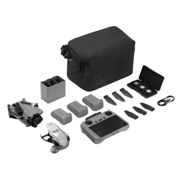
- DJI P4 Multispectral Drone
- Remote Controller
- Battery
- Charger
- Propellers
- Gimbal Protector
- RC Cable
- MicroSD Card
- Carrying Case
- Quick Start Guide
- Safety and Regulation Documents
- Takeoff Weight:
1487 g - Diagonal Distance (Propellers Excluded):
350 mm - Max Service Ceiling Above Sea Level:
19685 ft (6000 m) - Max Ascent Speed:
6 m/s (automatic flight); 5 m/s (manual control) - Max Descent Speed:
3 m/s - Max Speed:
31 mph (50 kph) (P-mode); 36 mph (58 kph) (A-mode) - Max Flight Time:
Approx. 27 minutes - Operating Temperature:
0° to 40° C (32° to 104° F) - Operating Frequency:
2.4000 GHz to 2.4835 GHz (Europe, Japan, Korea)
5.725 GHz to 5.850 GHz (Other countries/regions) - Transmission Power (EIRP):
2.4 GHz: < 20 dBm (CE / MIC / KCC)
5.8 GHz: < 26 dBm (FCC / SRRC / NCC) - Hover Accuracy Range:
RTK enabled and functioning properly:
Vertical: ± 0.1 m
Horizontal: ± 0.1 m
RTK disabled:
Vertical: ± 0.1 m (with vision positioning); ± 0.5 m (with GNSS positioning)
Horizontal: ± 0.3 m (with vision positioning); ± 1.5 m (with GNSS positioning) - Image Position Compensation:
The relative positions of the centers of the six cameras’ CMOS and the phase center of the onboard D-RTK antenna have been calibrated and are recorded in the EXIF data of each image.
- Ground Sample Distance (GSD):
- Formula: (H/18.9) cm/pixel
- H indicates the aircraft altitude relative to the area mapped (unit: m)
- Rate of Data Collection:
- Max operating area of approx. 0.63 km2 for a single flight at an altitude of 180 m
- GSD is approx. 9.52 cm/pixel
- Forward overlap rate of 80%
- Side overlap ratio of 60%
- Flight drains the battery from 100% to 30%
- Single-Frequency High-Sensitivity GNSS:
- GPS + BeiDou + Galileo[2] (Asia)
- GPS + GLONASS + Galileo[2] (other regions)
- Multi-Frequency Multi-System High-Precision RTK GNSS:
- Frequency Used:
GPS: L1/L2
GLONASS: L1/L2
BeiDou: B1/B2
Galileo[2]: E1/E5 - First-Fixed Time: < 50 s
- Positioning Accuracy:
Vertical: 1.5 cm + 1 ppm (RMS)
Horizontal: 1 cm + 1 ppm (RMS)
1 ppm indicates error with a 1 mm increase over 1 km of movement. - Velocity Accuracy: 0.03 m/s
- Frequency Used:
-
Controllable Range
-
Tilt: -90° to +30°
- Velocity Range:
≤ 31 mph (50 kph) at 6.6 ft (2 m) above ground with adequate lighting - Altitude Range:
0 - 33 ft (0 - 10 m) - Operating Range:
0 - 33 ft (0 - 10 m) - Obstacle Sensory Range:
2 - 98 ft (0.7 - 30 m) - Operating Environment:
Surfaces with clear patterns and adequate lighting (> 15 lux)
- Sensors:
Six 1/2.9” CMOS, including one RGB sensor for visible light imaging and five monochrome sensors for multispectral imaging.
Each Sensor: Effective pixels 2.08 MP (2.12 MP in total) - Filters:
Blue (B): 450 nm ± 16 nm
Green (G): 560 nm ± 16 nm
Red (R): 650 nm ± 16 nm
Red edge (RE): 730 nm ± 16 nm
Near-infrared (NIR): 840 nm ± 26 nm - Lenses:
FOV (Field of View): 62.7°
Focal Length: 5.74 mm (35 mm format equivalent: 40 mm), autofocus set at ∞
Aperture: f/2.2 - RGB Sensor ISO Range:
200 - 800 - Monochrome Sensor Gain:
1 - 8x - Electronic Global Shutter:
1/100 - 1/20000 s (visible light imaging)
1/100 - 1/10000 s (multispectral imaging) - Max Image Size:
1600×1300 (4:3.25) - Photo Format:
JPEG (visible light imaging) + TIFF (multispectral imaging) - Supported File Systems:
FAT32 (≤ 32 GB)
exFAT (> 32 GB) - Supported SD Cards:
microSD with a minimum write speed of 15 MB/s.
Max Capacity: 128 GB.
Class 10 or UHS-1 rating required - Operating Temperature:
0° to 40° C (32° to 104° F) - Remote Controller:
- Operating Frequency:
2.4000 GHz to 2.4835 GHz (Europe, Japan, Korea)
5.725 GHz to 5.850 GHz (Other countries/regions)[1] - Transmission Power (EIRP):
2.4 GHz: < 20 dBm (CE / MIC / KCC)
5.8 GHz: < 26 dBm (FCC / SRRC / NCC) - Max Transmission Distance:
FCC / NCC: 4.3 mi (7 km)
CE / MIC / KCC / SRRC: 3.1 mi (5 km) (Unobstructed, free of interference) - Built-in Battery:
6000 mAh LiPo 2S - Operating Current / Voltage:
1.2 A @ 7.4 V - Mobile Device Holder:
Tablets and smartphones - Operating Temperature:
0° to 40° C (32° to 104° F)
- Operating Frequency:
- Capacity:
5870 mAh - Voltage:
15.2 V - Battery Type:
LiPo 4S - Energy:
89.2 Wh - Net Weight:
468 g - Operating Temperature:
-10° to 40° C (14° to 104° F) - Charging Temperature:
5° to 40° C (41° to 104° F) - Max Charging Power:
160 W
- Voltage:
17.5 V - Operating Temperature:
5° to 40° C (41° to 104° F)
- Voltage:
17.4 V - Rated Power:
160 W
Company Vision
From intelligent drones to humanoid and companion robots, we bring innovation that empowers industries, creators, and communities for a smarter, connected future.

Trusted by Industry Leaders


%20Basic%20Combo%20Drone.webp&w=640&q=75)