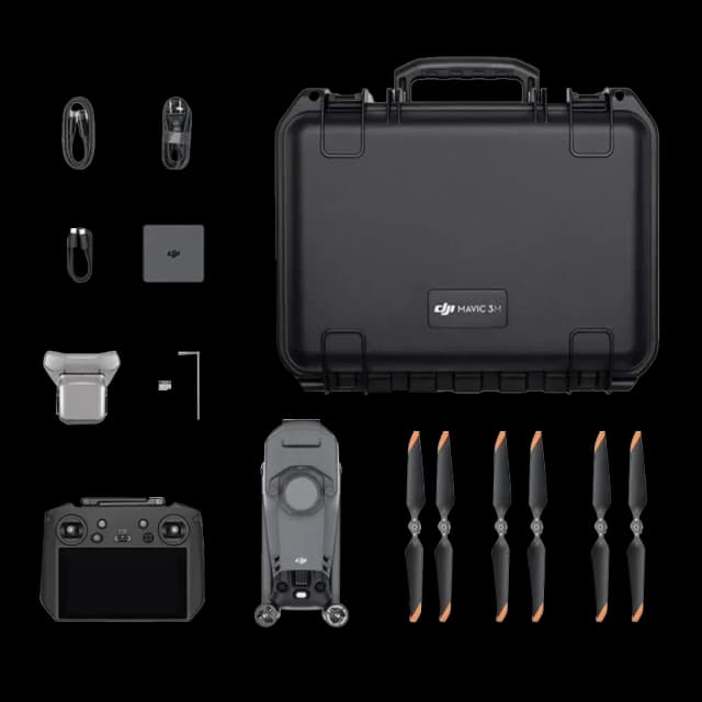
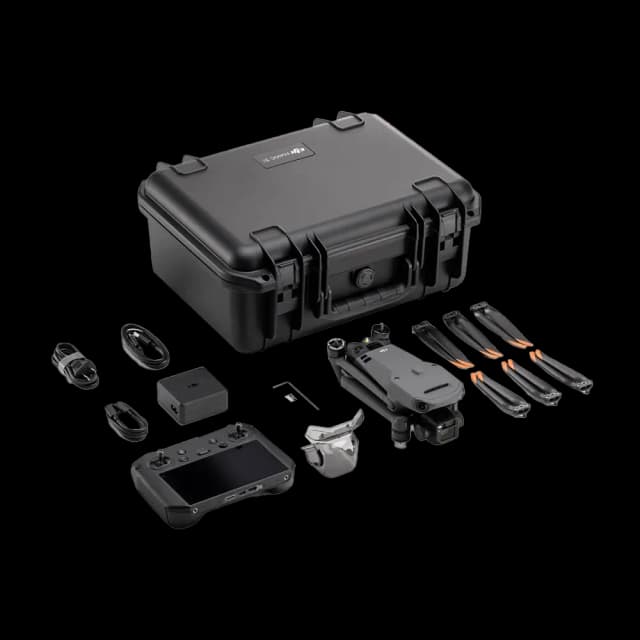
DJI Mavic 3 Thermal Enterprise Drone
Same day dispatch, Order before 2:30 PM
30 days easy returns
24 / 7 support service
Cash on Delivery option available
1-Year Software Warranty
Buy DJI Mavic 3 Thermal Enterprise Drone at the Best Price in India
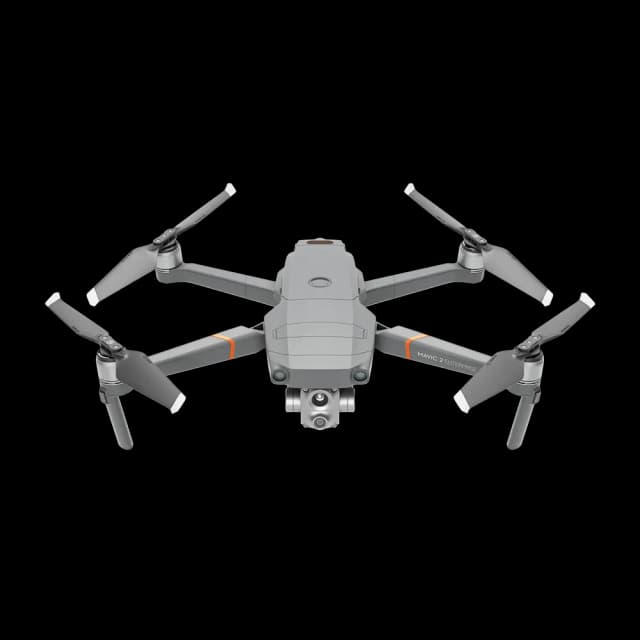
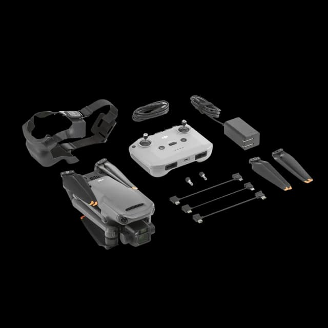
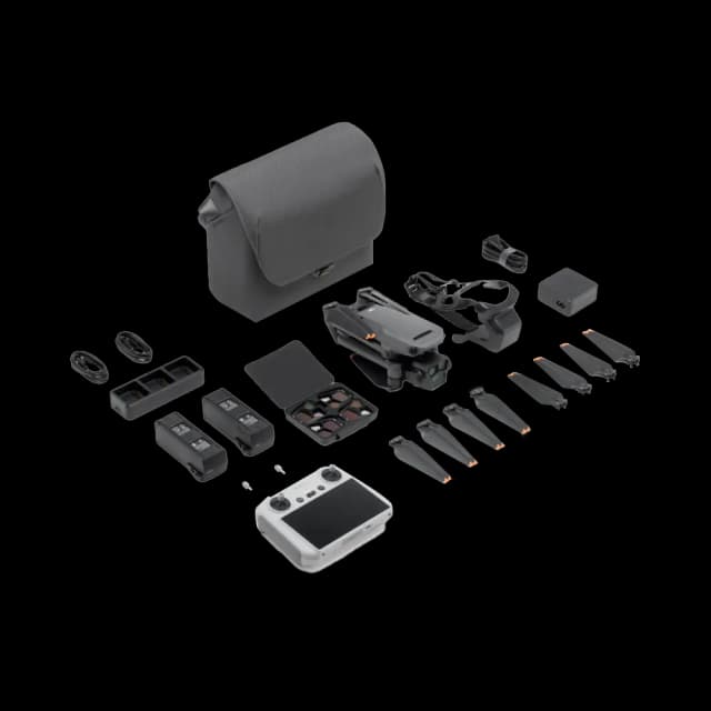
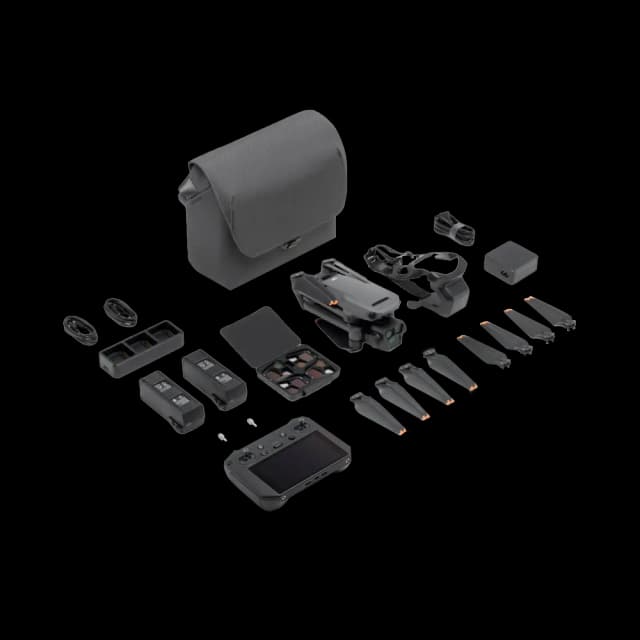
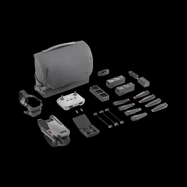
The DJI Mavic 3 Thermal Enterprise Drone (TE) is a cutting-edge aerial tool designed for professionals seeking advanced thermal imaging capabilities. Equipped with a dual camera system that combines high-resolution thermal and visual cameras, the Mavic 3 TE excels in a variety of critical applications, from search and rescue missions to precision agriculture and infrastructure inspection. Its thermal sensor captures detailed heat signatures, while the 4K visual camera ensures crisp, clear footage. Enhanced with automated flight paths, real-time data transmission, and an obstacle avoidance system, this drone is built for efficiency and safety. Its compact, foldable design and extended battery life make it highly portable and operational over vast areas, making the DJI Mavic 3 TE an indispensable asset for industry professionals.
Dual Camera System: The DJI Mavic 3 TE boasts a sophisticated dual camera system, integrating a high-resolution thermal camera for capturing precise thermal data alongside a 4K visual camera for detailed RGB imagery. This powerful combination is ideal for a multitude of applications, offering comprehensive insights from the air.
Advanced Thermal Imaging: Equipped with a state-of-the-art thermal sensor, the drone excels in detecting minute temperature variations, crucial for applications such as search and rescue, environmental monitoring, and infrastructure evaluation, providing essential data for critical decision-making.
Crisp 4K Visual Camera: The 4K RGB camera captures exceptionally detailed and clear visual footage, making it perfect for tasks requiring high-resolution imaging like detailed inspections, surveillance, and condition documentation across various sectors.
Seamless Image Switching: Operators can swiftly switch between thermal and visual feeds in real-time during flight, enhancing situational awareness and operational efficiency. This feature is invaluable in dynamic environments where rapid response and adaptability are key.
In-depth Image Analysis: Supported by advanced analysis software, the Mavic 3 TE enables comprehensive examination of thermal data. Features such as adjustable isotherm settings and precise temperature measurements provide deep insights, facilitating thorough assessments and informed interventions.
Automated Flight and Data Collection: Intelligent flight modes automate data collection processes, ensuring uniform coverage and consistent data capture across targeted areas. This automation is critical for efficient monitoring, analysis, and management of resources in agriculture, environmental conservation, and urban planning.
Extended Flight Duration: The drone’s enhanced battery technology offers extended flight times, allowing operators to conduct longer missions and cover vast areas without frequent stops for recharging. This increased efficiency is vital for large-scale operations and time-sensitive missions.
Robust Obstacle Avoidance: With an advanced obstacle avoidance system, the Mavic 3 TE ensures safe navigation in complex environments, significantly reducing the risk of collisions and enhancing the safety of both the drone and its operational surroundings.
Superior Connectivity and Transmission: Featuring a robust transmission system, the drone delivers stable, long-range transmission of thermal and visual feeds, ensuring operators have a clear and uninterrupted view of the data, which is crucial for precision tasks and detailed inspections.
Compact and Portable: Its foldable and compact design significantly enhances the drone’s portability, facilitating easy transportation and rapid deployment across diverse operational contexts, from emergency response scenarios to routine agricultural surveys.
Accessory Compatibility: The Mavic 3 TE’s compatibility with various accessories, including spotlights for night operations and loudspeakers for emergency communications, expands its utility across a wide range of professional tasks, enhancing its versatility and application in the field.
All-Weather Operation: Designed to withstand a variety of weather conditions, the drone ensures reliable operation and data collection in both hot and cold climates, guaranteeing its readiness and performance regardless of environmental challenges.
GPS Tagging: Every captured image and video is embedded with GPS location data, enabling precise mapping and tracking of thermal anomalies and points of interest. This feature is invaluable for coordinated response efforts, detailed mapping, and effective tracking in complex operational scenarios.
The DJI Mavic 3 Thermal Enterprise Drone (TE) sets a new standard for thermal and visual aerial imaging, offering an array of advanced features that cater to the needs of professionals in various industries. Its capabilities in providing detailed thermal and visual data, combined with its ease of use and versatility, make it an indispensable tool for enhancing operational effectiveness, safety, and decision-making.

A lightweight, compact, and a foldable design makes it easy to carry for solo operation, enabling fast deployments for more flexibility.

Optional loudspeaker, RTK Module, DJI Cellular Dongle, and other official accessories are available to do more in the air

Equipped with wide-angle lenses on all sides and APAS 5.0 for omnidirectional obstacle avoidance with zero blind spots.

45-min flight duration lets you cover more ground in a single flight to increase efficiency. Batteries charge fast with a 100W charging hub.

Equipped with a 56x hybrid zoom camera, a 4/3 CMOS wide-angle camera for precise mapping, and a thermal camera for inspecting heat sources, this device offers versatile imaging capabilities suited for detailed surveillance and complex analyses.
When you're looking to buy the DJI Mavic 3 Thermal Enterprise Drone Everse offers some standout advantages. First off, we provide the drone at the best price you'll find in India, ensuring you get great value for your money. Plus, your purchase comes in a securely sealed package, guaranteeing its condition upon arrival. With delivery times of just 5 to 7 days, we pride ourselves on being the fastest in the business, prioritizing your convenience. What's more, our commitment doesn't end with the sale—we have repair and service centers to assist you even after the warranty expires. Count on Everse for a smooth drone shopping experience and ongoing customer

Specifications
- Weight (with propellers, without accessories) [1]:
- DJI Mavic 3E: 915 g
- DJI Mavic 3T: 920 g
- Max Takeoff Weight:
- DJI Mavic 3E: 1,050 g
- DJI Mavic 3T: 1,050 g
- Dimensions:
- Folded (without propellers): 221×96.3×90.3 mm (L×W×H)
- Unfolded (without propellers): 347.5×283×107.7 mm (L×W×H)
- Diagonal Distance:
- 380.1 mm
- Max Ascent Speed:
- 6 m/s (Normal Mode)
- 8 m/s (Sport Mode)
- Max Descent Speed:
- 6 m/s (Normal Mode)
- 6 m/s (Sport Mode)
- Max Flight Speed (at sea level, no wind):
- 15 m/s (Normal Mode)
- Forward: 21 m/s, Side: 20 m/s, Backward: 19 m/s (Sport Mode) [2]
- Max Wind Speed Resistance:
- 12 m/s [3]
- Max Take-off Altitude Above Sea Level:
- 6000 m (without payload)
- Max Flight Time (no wind):
- 45 mins [4]
- Max Hover Time (no wind):
- 38 mins
- Max Flight Distance:
- 32 km
- Max Pitch Angle:
- 30° (Normal Mode)
- 35° (Sport Mode)
- Max Angular Velocity:
- 200°/s
- GNSS:
- GPS+Galileo+BeiDou+GLONASS (GLONASS is supported only when the RTK module is enabled)
- Hovering Accuracy:
- Vertical: ±0.1 m (with Vision System); ±0.5 m (with GNSS); ±0.1 m (with RTK)
- Horizontal: ±0.3 m (with Vision System); ±0.5 m (with High-Precision Positioning System); ±0.1 m (with RTK)
- Operating Temperature Range:
- -10° to 40° C (14° to 104° F)
- Internal Storage:
- N/A
- Motor Model:
- 2008
- Propeller Model:
- 9453F Propellers for Enterprise
- Beacon:
- Built into the aircraft
- Sensor:
- DJI Mavic 3E: 4/3 CMOS, Effective pixels: 20 MP
- DJI Mavic 3T: 1/2-inch CMOS, Effective pixels: 48 MP
- Lens:
- DJI Mavic 3E:
FOV: 84°
Format Equivalent: 24 mm
Aperture: f/2.8-f/11
Focus: 1 m to ∞ - DJI Mavic 3T:
FOV: 84°
Format Equivalent: 24 mm
Aperture: f/2.8
Focus: 1 m to ∞
- DJI Mavic 3E:
- ISO Range:
- DJI Mavic 3E: 100-6400
- DJI Mavic 3T: 100-25600
- Shutter Speed:
- DJI Mavic 3E:
Electronic Shutter: 8-1/8000 s
Mechanical Shutter: 8-1/2000 s - DJI Mavic 3T:
Electronic Shutter: 8-1/8000 s
- DJI Mavic 3E:
- Max Image Size:
- DJI Mavic 3E: 5280×3956
- DJI Mavic 3T: 8000×6000
- Still Photography Modes:
- DJI Mavic 3E:
Single: 20 MP
Timed: 20 MP
JPEG: 0.7/1/2/3/5/7/10/15/20/30/60 s
JPEG+RAW: 3/5/7/10/15/20/30/60 s
Smart Low-light Shooting: 20 MP
Panorama: 20 MP (raw image) - DJI Mavic 3T:
Single: 12 MP/48 MP
Timed: 12 MP/48 MP
JPEG: 2/3/5/7/10/15/20/30/60 s*
Panorama: 12 MP (raw image); 100 MP (stitched image)* Shooting 48MP photo does not support 2s interval
Smart Low-light Shooting: 12 MP
- DJI Mavic 3E:
- Video Resolution:
- H.264
4K: 3840×2160@30fps
FHD: 1920×1080@30fps
- H.264
- Bitrate:
- DJI Mavic 3E:
4K: 130 Mbps
FHD: 70 Mbps - DJI Mavic 3T:
4K: 85 Mbps
FHD: 30 Mbps
- DJI Mavic 3E:
- Supported File Formats:
- exFAT
- Photo Format:
- DJI Mavic 3E: JPEG/DNG (RAW)
- DJI Mavic 3T: JPEG
- Video Format:
- MP4 (MPEG-4 AVC/H.264)
- Sensor:
- 1/2-inch CMOS, Effective pixels: 12 MP
- Lens:
- FOV: 15°
Format Equivalent: 162 mm
Aperture: f/4.4
Focus: 3 m to ∞
- FOV: 15°
- ISO Range:
- DJI Mavic 3E: 100-6400
- DJI Mavic 3T: 100-25600
- Shutter Speed:
- Electronic Shutter: 8-1/8000 s
- Max Image Size:
- 4000×3000
- Photo Format:
- JPEG
- Video Format:
- MP4 (MPEG-4 AVC/H.264)
- Still Photography Modes:
- DJI Mavic 3E:
Single: 12 MP
Timed: 12 MP
JPEG: 0.7/1/2/3/5/7/10/15/20/30/60 s
Smart Low-light Shooting: 12 MP - DJI Mavic 3T:
Single: 12 MP
Timed: 12 MP
JPEG: 2/3/5/7/10/15/20/30/60 s
Smart Low-light Shooting: 12 MP
- DJI Mavic 3E:
- Video Resolution:
- H.264
4K: 3840×2160@30fps
FHD: 1920×1080@30fps
- H.264
- Bitrate:
- DJI Mavic 3E:
4K: 130 Mbps
FHD: 70 Mbps - DJI Mavic 3T:
4K: 85 Mbps
FHD: 30 Mbps
- DJI Mavic 3E:
- Digital Zoom:
- 8x (56x hybrid zoom)
- Thermal Imager:
- Uncooled VOx Microbolometer
- Pixel Pitch:
- 12 μm
- Frame Rate:
- 30 Hz
- Lens:
- DFOV: 61°
Format Equivalent: 40 mm
Aperture: f/1.0
Focus: 5 m to ∞
- DFOV: 61°
- Noise Equivalent Temperature Difference (NETD):
- ≤50 mK@F1.0
- Temperature Measurement Method:
- Spot Meter, Area Measurement
- Temperature Measurement Range:
- -20° to 150° C (-4° to 302° F, High Gain Mode)
0° to 500° C (32° to 932° F, Low Gain Mode)
- -20° to 150° C (-4° to 302° F, High Gain Mode)
- Palette:
- White Hot/Black Hot/Tint/Iron Red/Hot Iron/Arctic/Medical/Fulgurite/Rainbow 1/Rainbow 2
- Photo Format:
- JPEG (8-bit)
R-JPEG (16-bit)
- JPEG (8-bit)
- Video Resolution:
- 640×512@30fps
- Bitrate:
- 6 Mbps
- Video Format:
- MP4 (MPEG-4 AVC/H.264)
- Still Photography Modes:
- DJI Mavic 3T:
Single: 640×512
Timed: 640×512
JPEG: 2/3/5/7/10/15/20/30/60 s
- DJI Mavic 3T:
- Digital Zoom:
- 28x
- Infrared Wavelength:
- 8-14 μm
- Infrared Temperature Measurement Accuracy:
- ±2° C or ±2% (using the larger value)
Gimbal
- Stabilization:
- 3-axis (tilt, roll, pan)
- Mechanical Range:
- DJI Mavic 3E:
Tilt: -135° to 100°
Roll: -45° to 45°
Pan: -27° to 27° - DJI Mavic 3T:
Tilt: -135° to 45°
Roll: -45° to 45°
Pan: -27° to 27°
- DJI Mavic 3E:
- Controllable Range:
- Tilt: -90° to 35°
Pan: Not controllable
- Tilt: -90° to 35°
- Max Control Speed (tilt):
- 100°/s
- Angular Vibration Range:
- ±0.007°
- Type:
- Omnidirectional binocular vision system, supplemented with an infrared sensor at the bottom of the aircraft.
- Forward:
- Measurement Range: 0.5-20 m
- Detection Range: 0.5-200 m
- Effective Sensing Speed: Flight Speed ≤15 m/s
- FOV: Horizontal 90°, Vertical 103°
- Backward:
- Measurement Range: 0.5-16 m
- Effective Sensing Speed: Flight Speed ≤12 m/s
- FOV: Horizontal 90°, Vertical 103°
- Lateral:
- Measurement Range: 0.5-25 m
- Effective Sensing Speed: Flight Speed ≤15 m/s
- FOV: Horizontal 90°, Vertical 85°
- Upward:
- Measurement Range: 0.2-10 m
- Effective Sensing Speed: Flight Speed ≤6 m/s
- FOV: Front and Back 100°, Left and Right 90°
- Downward:
- Measurement Range: 0.3-18 m
- Effective Sensing Speed: Flight Speed ≤6 m/s
- FOV: Front and Back 130°, Left and Right 160°
- Operating Environment:
- Forward, Backward, Lateral, and Upward: Surface with a clear pattern and adequate lighting (lux >15)
- Downward: Diffuse reflective surface with diffuse reflectivity >20% (e.g. walls, trees, people) and adequate lighting (lux >15)
- Video Transmission System:
- DJI O3 Enterprise Transmission
- Live View Quality:
- Remote Controller: 1080p/30fps
- Operating Frequency [6]:
- 2.400-2.4835 GHz
- 5.725-5.850 GHz
- Max Transmission Distance (unobstructed, free of interference) [7]:
- DJI Mavic 3E:
- FCC: 15 km
- CE: 8 km
- SRRC: 8 km
- MIC: 8 km
- DJI Mavic 3T:
- FCC: 15 km
- CE: 8 km
- SRRC: 8 km
- MIC: 8 km
- DJI Mavic 3E:
- Max Transmission Distance (Obstructed) [8]:
- Strong Interference (dense buildings, residential areas, etc.): 1.5-3 km (FCC/CE/SRRC/MIC)
- Medium Interference (suburban areas, city parks, etc.): 3-9 km (FCC), 3-6 km (CE/SRRC/MIC)
- Low Interference (open spaces, remote areas, etc.): 9-15 km (FCC), 6-8 km (CE/SRRC/MIC)
- Max Download Speed [9]:
- 15 MB/s (with DJI RC Pro Enterprise)
- Latency (depending on environmental conditions and mobile device):
- Approx. 200 ms
- Antenna:
- 4 Antennas, 2T4R
- Transmission Power (EIRP):
- 2.4 GHz: <33 dBm (FCC), <20 dBm (CE/SRRC/MIC)
- 5.8 GHz: <33 dBm (FCC), <30 dBm (SRRC), <14 dBm (CE)
-
Capacity
-
5000 mAh
-
Standard Voltage
-
15.4 V
-
Max Charging Voltage
-
17.6 V
-
Type
-
LiPo 4S
-
Chemical System
-
LiCoO2
-
Energy
-
77 Wh
-
Weight
-
335.5 g
-
Charging Temperature
-
5° to 40° C (41° to 104° F)
- What makes the DJI Mavic 3T Worry Basic Combo a monumental advancement in aerial thermal imaging?
The DJI Mavic 3T Worry Basic Combo offers high efficiency, unmatched precision, and portability. Engineered for search and rescue, infrastructure inspection, and environmental monitoring, it ensures reliable and exceptional image quality, elevating operational capabilities to new heights.
-
Elevating Aerial Thermal Imaging
The Mavic 3T is a comprehensive solution for aerial thermal imaging. It features a sophisticated thermal camera and a high-resolution visual camera, allowing users to capture detailed thermal data and crisp visuals simultaneously.
-
Why Choose the DJI Mavic 3T Worry Basic Combo?
The dual-camera system allows seamless switching between thermal and visual feeds, offering a comprehensive overview. It is ideal for identifying heat sources, inspecting solar panels, and monitoring wildlife with precision and clarity.
-
Unmatched Efficiency and Precision
The Mavic 3T's thermal camera provides accurate temperature measurements, and combined with high-resolution imagery from the visual camera, it offers unmatched detail and efficiency compared to traditional methods.
-
Portable Design for Field Operations
Lightweight and compact, the Mavic 3T is easy to deploy in remote locations. Quick setup and launch capabilities ensure rapid response in time-sensitive missions.
-
Enhanced Operational Capabilities
The drone features extended flight time, a robust transmission system, and advanced flight modes. It covers large areas efficiently, maintains stable communication, and navigates challenging terrains autonomously.
-
Why Everse.in is Your Ideal Partner
Purchasing from Everse.in guarantees competitive pricing and authentic products with comprehensive customer support. They offer the latest DJI technology, expert advice, and after-sales service.
-
Revolutionizing Industries with Thermal Imaging
The Mavic 3T offers versatile solutions for various sectors, including agriculture, public safety, and environmental monitoring. It enhances efficiency and innovation across these industries.
-
Investing in Advanced Aerial Technology
Investing in the Mavic 3T is investing in the future of aerial technology. It meets the growing demand for sophisticated thermal imaging, offering high-quality data capture and workflow enhancement.
-
Conclusion: Transforming Operations with DJI Mavic 3T Worry Basic Combo
The Mavic 3T represents a leap in aerial thermal imaging integration. With advanced features and unmatched precision, it supports a wide range of missions, providing technology and reliability for exceptional results.
-
Embark on a new era of aerial thermal imaging with the DJI Mavic 3T Worry Basic Combo. Visit Everse.in today and discover how this innovative drone can elevate your projects and operational capabilities to unprecedented levels.
- What makes the DJI Mavic 3 TE ideal for emergency response operations?
The Mavic 3 TE’s advanced thermal imaging capability allows for the detection of heat signatures from people or animals in various conditions, making it invaluable for search and rescue operations. Its ability to capture high-quality visual and thermal data simultaneously ensures rapid assessment and response in emergencies.
- Can the Mavic 3 TE be used for agricultural purposes?
Absolutely. The thermal imaging technology can monitor crop health, identify irrigation needs, and detect pest or disease outbreaks, making the Mavic 3 TE a powerful tool for precision agriculture and sustainable farming practices.
- How does the dual camera system benefit infrastructure inspections?
The dual camera system, featuring both thermal and 4K visual sensors, enables inspectors to visually identify structural issues and verify them with thermal data. This comprehensive approach is critical for assessing energy efficiency, detecting water leaks, or identifying electrical faults.
- What is the flight time of the DJI Mavic 3 TE?
The Mavic 3 TE boasts an extended flight time, allowing operators to conduct thorough inspections, surveys, or monitoring tasks on a single charge. This capability is crucial for covering large areas efficiently.
- How does the obstacle avoidance system work?
The drone’s obstacle avoidance system utilizes sensors to detect and navigate around obstacles in its path, ensuring safe flight in complex environments. This system is vital for protecting the drone and its surroundings during operation.
- Is the Mavic 3 TE difficult to transport?
No, the Mavic 3 TE features a compact and foldable design, making it highly portable and easy to deploy. This design is particularly beneficial for professionals who need to transport the drone to various locations for field operations.
- Can the thermal data be analyzed in real-time?
Yes, the Mavic 3 TE supports real-time transmission of thermal data, allowing operators to analyze and interpret heat signatures immediately. This feature is essential for making quick decisions in time-sensitive situations.
- Is the DJI Mavic 3 TE weather-resistant?
Designed to operate in various weather conditions, the Mavic 3 TE ensures reliable performance in both hot and cold climates, offering flexibility for year-round operations across different industries.
- How accurate is the GPS tagging feature?
The GPS tagging feature provides precise location data for every image and video captured, facilitating accurate mapping and tracking of thermal events and areas of interest, enhancing situational awareness and operational coordination.
- What applications can benefit from the Mavic 3 TE’s thermal and visual imaging capabilities?
The Mavic 3 TE is versatile and can be utilized across multiple sectors, including emergency response, precision agriculture, infrastructure inspection, environmental monitoring, and security. Its imaging capabilities provide critical data for informed decision-making and operational efficiency.
Company Vision
From intelligent drones to humanoid and companion robots, we bring innovation that empowers industries, creators, and communities for a smarter, connected future.

Trusted by Industry Leaders